Pages

Showing posts with label Geology. Show all posts

Thursday, October 18, 2018

Earth's Records

Earth has many records like the largest desert on Earth, tallest geyser, tallest waterfall, largest tsunami, etc. Which includes its height, depth, altitude, how long, how large, and more. If you haven't seen my last post, 'Are There Volcanoes in Our Solar System?', click on the link and check it out. First, we are going to know about our tallest mountain.

Earth's Tallest Mountain
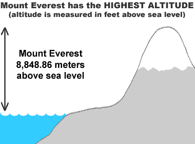
Highest Altitude

Mount Everest - Highest Altitude

People around the world call Mount Everest as the tallest mountain in the world. But, do you know why Mount Everest is named as the tallest mountain in the world? It's because of the highest elevation above sea level. The peak of the mountain is 8,850 metres above the sea level. So that means that Mount Everest is not the tallest mountain in the world. Now let's talk about the tallest mountain. 

Highest Mountain


What does tallest mountain mean?
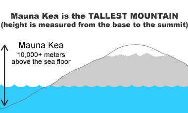
Really, the tallest mountain is Mauna Kea. Well, Mauna Kea's altitude is 4,205 metres, lower than Mount Everest. Manua Kea is above 10,000 metres above the seafloor. Now, compare Mount Everest's height (8,850) and Mauna Kea's height (10,000). If you've learnt something new about Earth's highest mountain, which is Mauna Kea, comment down below. 


Earth's Tallest Waterfall


Angel Falls
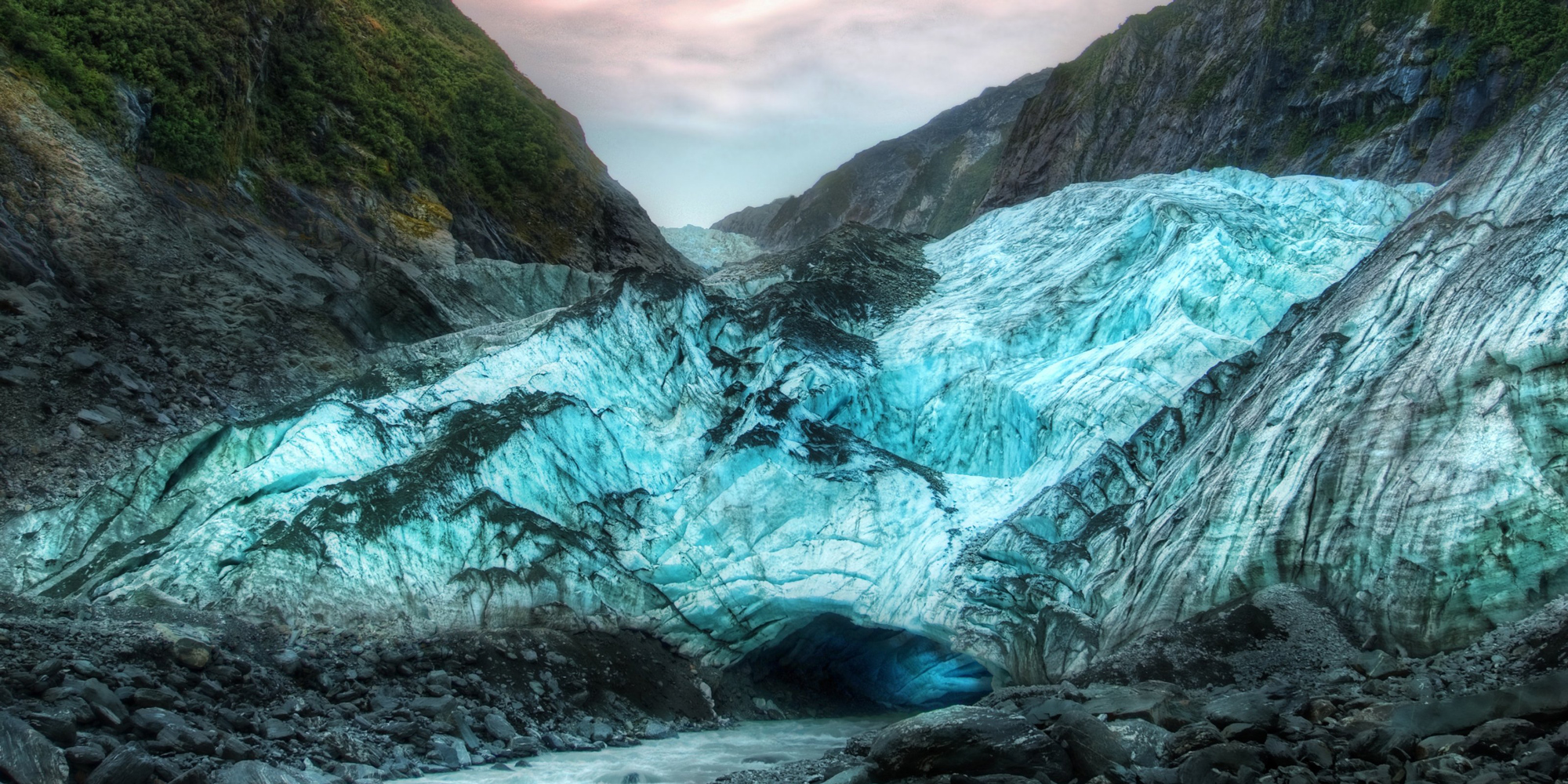
Ever thought where and how tall the tallest waterfall in the world? Angel Falls is the tallest waterfall in the world, with a height of 979 metres. The longest drop is 807 metres. Angel Falls is a UNESCO World Heritage Site. Angel Falls is located in Venezuela. The waterfall is surrounded by many types of minerals and rocks. Angel Falls is almost 19 times taller than Niagara Falls. If you've learnt something new about Earth's tallest waterfall, comment down below.


Earth's Largest Earthquake


largest earthquake - damage at Valdivia
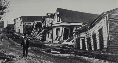
The damage of Valdivia
The largest earthquake was recorded on May 22, 1960. It occurred in Valdivia, Chile. The earthquake is known as the Valdivia earthquake or Great Chilean earthquake. The earthquake was from 9.4 to 9.6 Mw, the earthquake occurred in the afternoon. It lasted for about 10 minutes. The depth of the earthquake was 25 km. 5,000 people died and 2,000,000 people were homeless. After days after the earthquake, there was a tsunami in Hawaii, Philippines and Japan. Hundreds of people died. Have you learnt anything about the largest earthquake recorded? Comment down below!! Next is about Earth's longest river.


Earth's Longest River


Image result for nile river
Scientists question, is Amazon longer than the Nile? The Amazon is larger than the Nile by volume. Let's know information about these rivers.

First, the Nile. The Nile is considered as the longest river in the world. The Nile starts from the Nile delta, the river reaches the Mediterranean Sea. The river is 6,695 kilometres long. The Nile River flows through 11 countries: Tanzania, Uganda, the Democratic Republic of the Congo, Rwanda, Burundi, Ethiopia, Kenya, Eritrea, South Sudan, Sudan and Egypt.  Now, the Nile no longer floods each year, it's because the Aswan High Dam was built in 1970.

Image result for amazon river and nile riverThe Amazon River is the longest river in South America. The Amazon River carries the most water than any other river in the world. The river is responsible for ⅕ for 20% for Earth's water. The Brazilian scientists have been to a 14-day expedition to the Amazon River, they extended the river's length. Now the Amazon River is 297 kilometres longer than the Nile. The Amazon River is 6,992 kilometres long.

So now we know that the Amazon River is the longest river in the world. If you learnt that the Amazon River is the longest river in the world. Comment down below. Share this information to your friends and family. Next is about the Highest Mountain in each continent.

Highest Mountain in Each Continent


Highest Mountain in Oceania
Image result for mount wilhelm
Mount Wilhelm is the tallest mountain in Oceania. It is located in Papua New Guinea. The height of the mountain is 4,509 metres. 


Highest Mountain in Asia
Mount Everest
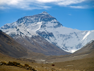
As you know the highest mountain in Asia is Mount Everest. The mountain is located in the border of Nepal and China. 


Highest Mountain in Africa

Mount Kilimanjaro
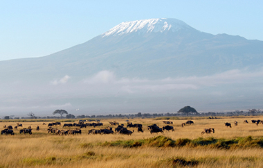
Mount Kilimanjaro is the tallest mountain in Africa. Actually, Mount Kilimanjaro is also a volcano, with three volcanic shields. The hight of the mountain is 5,895 metres.


Highest Mountain in Europe

Mount Elbrus
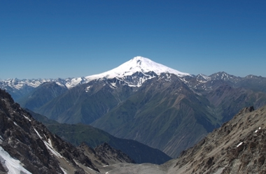
Mount Elbrus is the tallest mountain in Europe. Mount Elbrus is located in Russia. The height of the mountain is 5,642 metres.


Highest Mountain in North America

Mount McKinley (Denali)
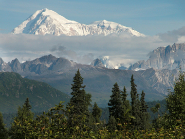
Mount McKinley is the tallest mountain in North America. Mount McKinley is located in Alaska. The height of the mountain is 6,190 metres.  


Highest Mountain in South America

Mount Aconcagua
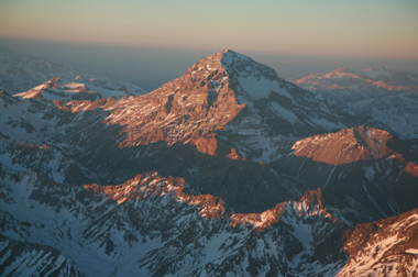
Mount Aconcagua is the tallest mountain in South America. The mountain is the tallest mountain in the western and southern hemisphere. The mountain is located in Mendoza, Argentina. 


Highest Mountain in Antartica

Vinson Massif, Antarctica
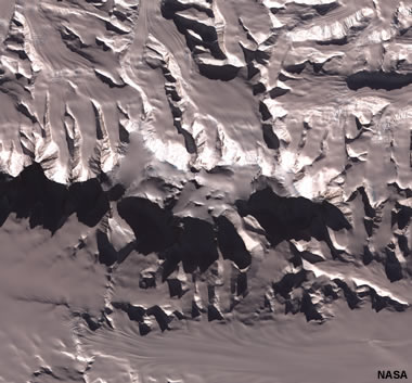
Vinson Massif is the tallest mountain in Antartica. The mountain is 21 kilometres long and 12 kilometres wide. The mountain is 1,200 kilometres away from the South Pole.


I hope you like my post about Earth's Records. Comment down below if you've learnt something new about my post. Because I've learnt somethings too. If I've missed something out. Please comment down what it is. If you know more Earth records comment down below. Have a cool day!! Bye!!

Saturday, October 13, 2018

Are There Volcanoes in Our Solar System?

Are there Space Volcanoes? Have you heard of Space Volcanoes? What planet are they on? Are Space Volcanoes beyond our Solar System?

Well, Earth wasn't the only planet in the Solar System with volcanoes. There are also Space Volcanoes which are on other planets and moons.

Image result for io moon
Io - Jupiter's Moon
Credithttps://solarsystem.nasa.gov/
Now, when it comes to Volcanoes in our Solar System then people think of Io. Io is a moon of Jupiter. Io is the innermost moon of the Galilean Moons. Galilean Moons are moons discovered by Galileo Galilei. So back to Io, it is the fourth largest moon of Jupiter. Io was discovered on 8 January 1610 by Galileo Galilei. The moon has the most density of all of the moons. Io has the least amount of water of any astronomical object in the Solar System. Io is the first moon after discovering Earth's Moon. The moon's orbital period is 42 hours. This means that it takes 42 hours to complete one orbit around Jupiter. Io is the most volcanically active spot in the Solar System. Io is slightly smaller than our Moon. Voyager and Cassini have flybys of Io and studied more about their volcanoes. Galileo (spacecraft) has orbited Jupiter. The recent flyby was New Horizons which was on the way to Pluto.

So, here is a list of volcanoes around the Solar System. The explanation mark shows volcanoes on these planets in our Solar System.


schematic of solar system

  • Venus
    • Like Io, Venus is covered with volcanoes. Venus has around 1,000 volcanoes.
  • Earth
    • Earth's Volcanoes
  • Earth's Moon
    • Lunar Dome
    • Mons Rümker
    • Mons Hansteen
  • Mars
    • Olympus Mons, which is the tallest mountain in our Solar System is also a volcano. The mountain is three times larger than Mount Everest. 
  • Jupiter
    • Ganymede
    • Io
    • Europa
    • Callisto
  • Saturn
    • Enceladus 
    • Titan
  • Neptune
    • Triton

What I've Learnt


  • Io was discovered on 8 January 1610.
  • Io has the most density than the other moons of Jupiter. 
  • Io has the least amount of water than any other astronomical object in the Solar System.
  • Io is the first moon after discovering Earth's Moon. 
  • Io's orbital period is 42 hours.
  • Io is the most volcanically active spot in the Solar System.
  • Io is slightly smaller than our Moon. 
  • Voyager and Cassini have flybys of Io and studied more about their volcanoes. Galileo (spacecraft) has orbited Jupiter. The recent flyby was New Horizons which was on the way to Pluto. 
  • Venus is covered with volcanoes.
  • Venus has around 1,000 volcanoes.
  • Earth's moon has three volcanoes, Lunar Dome, Mons Rümker, Mons Hansteen.
  • Olympus Mons is a volcano. 
  • Ganymede, Callisto, Titan and Triton is a volcano.

I hope you like my post. Comment down below if you've learnt something new. Have a cool day!! Bye!!

Friday, October 12, 2018

Where are Earth's Volcanoes?

For the last few posts, I've been posting about Volcanoes. If you haven't seen my two posts about Volcanoes, The Ring of Fire and Volcanoes!! 🌋, then check it out!! There are about 1,500 active volcanoes in the world. Many of the volcanoes are in the Ring of Fire. There are 452 volcanoes in the Ring of Fire. That is 75% of Earth's volcanoes. Below is a map of volcanoes on Earth. As you see most of the volcanoes are around the Ring of Fire. If you know any volcanoes that aren't on the map, then please comment down below what volcano it is. If I find any volcano then I will update it. I hope you like my post about Earth's Volcanoes!! Comment down below if you've learnt something new. Have a cool day!! Bye!!

Cool Facts:
  • There are 76 volcanoes on Indonesia, this makes the country with the most volcanoes.
  • The word 'Volcano' comes from the Volcano name 'Vulcan' the Roman God of Fire.


What Have I've Learnt?


  • There are volcanoes on Northern Africa and Central Africa.
  • There are volcanoes on Iceland.
  • There are volcanoes on small islands. 
  • Alaska has heaps of volcanoes on the Aleutian Islands.
  • Tamu Massif is a volcano underground/under the sea.
  • The word 'Volcano' comes from the Volcano name 'Vulcan' the Roman God of Fire.

Wednesday, October 10, 2018

Volcanoes!! 🌋

For today's post, we are going to look at Volcanoes 🌋. The last post, that I had posted was about the Ring of Fire. To know more information about volcanoes, watch this video about Volcanoes from National Geographic.


In the video, it includes information about my posts about,


Here I'm going to post about how Volcanoes form. I found a video from my Plate Tectonics blog post of how volcanoes explode. By the video from National Geographic, there is information about how Volcanoes explode if you haven't seen it.


schematic of the three ways volcanoes can form
Volcanoes form from rising magma. Magma rises in three ways.


Have you seen someone so close to a volcano? Here is a spectacular volcano video | National Geographic. They have used drones to look from above the volcano. Watch this!!


This video was recorded at Marum Crater, Ambrym Island in Vanuatu. Which 1,334-metre active volcano.


Now here's another video about an active volcano in Hawaii. This video is also from National Geographic. Watch this!!


Lava bubbles up from Kīlauea Volcano in Hawaii
Volcanoes National Park.
Credit: Scott Horvath, USGS.
The video is recorded in Kilauea. Here's information about Kilauea. Kilauea is a shield volcano in Hawaii. It is the most active volcano out of the four in the Island of Hawai'i. The volcano is about 1,247-metres high. Kilauea is located on the southern shore of the island. The volcano is about between 300,000 and 600,000 years old. Did you know that Kilauea has been erupting continuously for more than 30 years!!


Lava fountain at Kilauea Volcano, Hawai`i.
An image of Kilauea erupting in Hawaii.
Credit: J.D Griggs, USGS

Volcanoes Around Us


One of the reasons New Zealand is famous is because of their volcanoes. New Zealand has famous volcanoes like the White Island. Here are volcanoes in New Zealand. 
New Zealand Volcanoes
Volcanoes in New Zealand
Credit: gns.cri.nz

  1. Mount Ruapehu
  2. Mount Tongariro
  3. Mount Taranaki
  4. White Island
  5. Raoul Island
  6. Mount Ngauruhoe
  7. Taupo Volcanic Zone
  8. Mayor Island
  9. Mount Tarawera
  10. Auckland Volcanic Field
  11. Brothers Volcano
Here is a link to gns.cri.nz, for Volcano Geology and Hazards in New Zealand.


What I've Learnt?


  • Marum Crater, Ambrym Island in Vanuatu is 1,334-metre high volcano.
  • Kilauea is the most active volcano out of the four in the Island of Hawai'i.
  • Kilauea is about 1,247-metres high.
  • Kilauea is located on the southern shore of the island. 
  • Kilauea is about between 300,000 and 600,000 years old. 
  • Kilauea has been erupting continuously for more than 30 years!!
I hope you like my post about Volcanoes 🌋!! Comment down if you've learnt something new. Have a cool day!! Bye!!

Wednesday, October 3, 2018

The Ring of Fire!!

For today's post, we are going to look at the Ring of Fire. Do you know what is the Ring of Fire? Where is it? What it does? Here's information about the Ring of Fire. I hope you like my post. Comment down below if you've learnt something new like me. Have a cool day!! Bye!!


Map of the Pacific Ring of Fire
  • The Ring of Fire is in the Pacific Plate.
  • The Ring of Fire is also called as the Circum-Pacific Belt. 
  • The Ring makes 75% of the world's volcanoes and 90% of its earthquakes. It has 452 volcanoes.
  • Most of the volcanoes are underground.
  • The Ring of Fire covers around the Pacific Ocean shown in the picture on the right. It covers countries,
    • New Zealand, Indonesia, Papua New Guinea, Phillippines, Japan, Taiwan, Russia, Japan, Alaska, Canada, United States, Mexico, Chile, Peru, Guatemala, Tuvalu, Kiribati, Malaysia, Fiji, Tina, Soloman Islands, Micronesia, Singapore, Samoa, Bolivia, Nicaragua, Colombia, Panama, Ecuador, El Salvador and Costa Rica.
  • The Ring of Fire is 40,000 km.
  • It lies on many tectonic plates. Link on my blog post of Tectonic Plates which gives you information about it.
  • These volcanoes are made because of Plate boundaries.

There are major volcanoes in the Ring of Fire.

  • Mt Fuji
  • The Andes
  • Mt St Helens
  • Mt Ruapehu
  • Popocatépetl
  • Krakatoa
  • Aleutian Islands (a chain of islands in Alaska)

The Ring of Fire has the deepest ocean trench, Mariana Trench. Which is located in the western North Pacific Ocean. Guam is 538 km away from Challenger Deep (which is the southern end of the Mariana Trench and the deepest point of Earth). The Challenger Deep is just around 11,000 m (10,994 m).

Here's a video from Vox about the Natural Disasters around the Ring of Fire. | Vox


Here is a video about Earthquakes. | National Geographic


Here is a video about Volcanoes. | National Geographic


What I've Learnt

  • The Ring makes 75% of the world's volcanoes and 90% of its earthquakes. It has 452 volcanoes.
  • The Ring of Fire is 40,000 km.
  • It lies on many tectonic plates.
  • These volcanoes are made because of Plate boundaries.
  • Guam is 538 km away from Challenger Deep.
  • The Challenger Deep is in the southern end of the Mariana Trench.

Monday, October 1, 2018

Rotorua

For today's post, we are going to look at Rotorua. So we had to make a guide about Rotorua. If you haven't seen my posts about the trip of Rotorua, check it out! Day 1, Day 2, Day 3, Day 4, Day 5. If you haven't commented on my 'I Need Your Help!' post please do. If you have, then, Thank You. I hope you like this post. Comment down if you've learnt something new. Have a cool day!! Bye!!

So, Rotorua is famous for its geothermal activity. Here are facts about Rotorua:


    Image result for rotorua lonely planetImage result for rotorua lonely planet
  1. Rotorua is famous for its geothermal activity.
  2. Rotorua is the 10th largest urban area.
  3. The average depth of Lake Rotorua is 10 metres.
  4. The Lady Knox Glacier in Wai-O-Tapu erupts every day at 10:15am.
  5. There are seven geothermal fields in Rotorua.
  6. Waimangu Volcanic Valley scenic reserve is popular because it is the youngest geothermal system on Earth.
  7. The average temperature of Rotorua is in the range from 22 - 26℃ in summer and in the winter the range is from 10 - 16℃. 
  8. There are three volcanoes in Rotorua (which are located in Tongariro National Park).
  9. Rotorua's nickname is the Sulfur City.
  10. 34% of Rotorua's population is Māori.

Information - What to do


What I've Learnt

  • Rotorua is the 10th largest urban area.
  • The average depth of Lake Rotorua is 10 metres.
  • There are seven geothermal fields in Rotorua.
  • Waimangu Volcanic Valley scenic reserve is popular because it is the youngest geothermal system on Earth.
  • The average temperature of Rotorua is in the range from 22 - 26℃ in summer and in the winter the range is from 10 - 16℃. 
  • There are three volcanoes in Rotorua (which are located in Tongariro National Park).
  • Rotorua's nickname is the Sulfur City.
  • 34% of Rotorua's population is Māori.

Thursday, September 13, 2018

Want to go to Yellowstone National Park?

For today's post, we are looking at Yellowstone National Park. We are looking at the best places to visit at Yellowstone National Park. Do you know where is Yellowstone National Park? Yellowstone National Park is in Wyoming (mostly), Montana and Idaho - United States of America. Here are things to do in Yellowstone National Park.

  • Grand Prismatic Spring
  • Old Faithful
  • Yellowstone Caldera
  • Upper Yellowstone Falls
  • Yellowstone Lake
  • Grand Canyon of the Yellowstone
  • Morning Glory Pool
  • Tower Fall
  • Firehole River
  • Castle Geyser
  • Grizzly & Wolf Discovery Centre
  • West Thumb Geyser Basin
  • Mount Washburn

InDepth: Waters of Yellowstone | Yellowstone NPS


Basic Information


Address: Yellowstone National Park Headquarters


2 Officers Row
Yellowstone National Park Headquarters 
Yellowstone National Park, WY 82190

Entrance Fees:


Yellowstone (non-commercial vehicle) - $35.00 

Yellowstone (motorcycle or snowmobile) - $30.00

Yellowstone (individual on foot, bicycle, etc.) - $20.00

Visitor Centres


  1. Albright Visitor Centre
  2. Canyon Visitor Educational Centre
  3. Grant Visitor Centre
  4. Museum of the National Park Ranger
  5. Fishing Bridge Visitor Centre & Trailside Museum
  6. Madison Information Station & Trailside Museum
  7. Norris Geyser Basin Museum & Information Station
  8. Old Faithful Visitor Educational Centre
  9. West Thumb Information Station
  10. West Yellowstone Visitor Information Centre (NPS Desk)
  11. West Yellowstone Visitor Information Centre

Facts | yellowstonenationalpark.com & nps.gov


  • Yellowstone National Park is the first national park.
  • Yellowstone National Park was established on 1 March, 1872.
  • 9 visitor centres
  • The size of Yellowstone National Park is 2,219,789 acres. It's larger than Delaware and Rode Island combined.
  • The park is covered by 5% water, 15% grassland and 80% forests.
  • Norris Geyser is the hottest geyser in Yellowstone National Park.

10 Tips of What to do at Yellowstone National Park


  1. Visit Yellowstone Lake in the Afternoon.
  2. See Old Faithful in the early morning or in the evening.
  3. See the Grand Prismatic just a few kilometres away from Old Faithful.
  4. Take a hike.
  5. Look for wildlife at the right time. The best chance of spotting the park's legendary bison as well as other critters in the early morning or evening.
  6. Bring binoculars
  7. Explore Lamar Valley.
  8. Stop at the visitor centres.
  9. Look at the stars. Go outside after dark.
  10. Carry a flashlight at night.

Videos | National Geographic


Here is the top five must attractions in Yellowstone National Park | National Geographic


How Animals and Humans Clash and Coexist in Yellowstone | National Geographic


Yellowstone: An American Treasure | National Geographic


Yellowstone's Water "Secrets" | National Geographic


Stunning Footage: Epic Animal Migrations in Yellowstone | National Geographic


5 Iconic Animals of Yellowstone | National Geographic


I hope you like my post. Comment down if you have learnt something new or want to go to Yellowstone National Park! Have a cool day!! Bye!!

Sunday, September 9, 2018

Where's New Zealand's Glaciers?

Image result for new zealand glaciers
New Zealand's Glacier
Image result for new zealand glaciers
Helicopter Passing Through the Southern Alpers.
For today's post, we are looking at New Zealand's Glaciers. Do you know what are glaciers? Glaciers begin to form when snow stays in the same spot all year round. Enough snow gathers to transform into ice. One of the things that New Zealand is famous for is its glaciers. There are three famous glaciers in New Zealand are Franz Josef Glacier, Fox Glacier and the Tasman Glacier. There are also more famous glaciers in New Zealand. So I've made a list below of glaciers in New Zealand.

Now I'll tell you facts about the glaciers in New Zealand.


  • New Zealand was used to be one island of Glaciers.
  • Mt Ruapehu holds 18 glaciers on one volcano.
  • You can find gold on the river beds, streams and beaches near the glaciers.
  • By 2100, Franz Josef would shrink by 38%.
  • Franz Josef and Fox Glaciers cause flash floods.
  • There are two planes discovered inside glaciers.


What I've Learnt


  • Glaciers begin to form when snow stays in the same spot all year round. Enough snow gathers to transform into ice.
  • Franz Josef Glacier, Fox Glacier and Tasman Glacier are the most famous glaciers in New Zealand.
  • New Glaciers in New Zealand.
  • Mt Ruapehu is a glacier.
  • New Zealand was used to be one island of glaciers.
  • Mt Ruapehu holds 18 glaciers.
  • We can find gold on the river beds, streams and beaches near the glaciers.
  • By 2100, Franz Josef would shrink by 38%.
  • Franz Josef and Fox Glaciers cause flash floods.
  • There are two planes discovered inside glaciers.

Saturday, September 1, 2018

Was Earth Different?

For today's post, we are looking at how was Earth a few million years ago. Was Earth the same as before? Has Earth changed? I'll tell you about it in this post. If you haven't seen my last two posts, 'What's Inside Earth' and 'Plate Tectonics', check it out. If you don't know, I have started a new science badge of Geology, so check it out. This post is about the continental drift. First, watch how Earth started and how it is today. Has it changed a lot? Watch it below ⬇️. I hope you like this post. Comment down below if you've learnt something new. Have a cool day!! Bye!!


Quiz


Here's a quiz for you of the video. Comment down below to answer! Be the first one to answer!

  • When was the first sight of New Zealand?
  • Is the supercontinent Arctica relate to Antarctica or the Arctic?
  • What supercontinent was when it was -2018 Myr?
  • Was Eon, Era and Period were it at the present day (today)?
  • How long was Pangaea for?
  • Where was the most land in the supercontinent Gondwana?
  • Which country went from Antarctica to Asia, that made the Himalayas?
  • Was Australia connected to Antartica?
  • Where was North America when Pangaea ended?
  • How long did South America and Africa attached together?

Pangaea


Fossil patterns across Gondwanaland

Alfred Wegener

Around 300 million years ago, Earth hadn't had the seven continents that we have now, but instead, there was one massive supercontinent, Pangaea. Pangaea was the most recent supercontinent. Alfred Wegener convinced that Earth's continents were once part of a supercontinent, Pangaea. Alfred trained as an astronomer, used botany, biology and geology to explain Pangaea and the continental drift. One example is fossils of the ancient reptile mesosaurus that are only found in South America and southern Africa. Mesosaurus is a reptile that is freshwater and it is just only one metre long, the reptile couldn't have swum the Atlantic Ocean.

Below is a video from Khan Academy showing Pangaea's idea and some evidence about it. Next, we are going to look at the first supercontinent.


The First Supercontinent


The first known supercontinent is Vaalbara. There is evidence of the first cratons in South Africa and Western Australia. The crust from Vaalbara is back 2.7 to 3.6 billion years ago.

Vaalbara's name comes from two cratons which were believed to be combined about 3.1 billion years ago. The first craton which now is in South Africa named Kaapvaal Craton. The second craton is the Pilbara craton which is in Pilbara, West Australia. Approximately 2.5 billion years ago the supercontinent split apart from each other. Their drift routes present additional evidence that they were once connected.


What I've Learnt

  • About the fossil patterns that were across South America, Africa, India, Antarctica and Australia.
  • Alfred Wegener had the first theory about the continental drift.
  • Alfred Wegener tranined as an astronomer.
  • Mesosaurus was a reptile that was only found in South America and southern Africa.
  • Mesosaurus is only one metre long.
  • The first cratons are in South Africa and Western Australia.
  • The crust from Vaalbara is back 2.7 to 3.6 billion years ago.
  • Vaalbara's name comes from two cratons.
  • South Africa's craton name is Kaapval Craton.
  • Western Australia's craton name is Pilbara Craton.
  • Around 2.5 billion years ago the supercontinent split apart.

Sunday, August 26, 2018

Plate Tectonics

For this post, we are looking at Earth's Plate Tectonic. This is my second post of the Geology Science Badge. If you haven't seen my last post, 'What's Inside Earth?', check it out. This post is about the crust of the Earth and how Earth's crust moves. What is the Plate Tectonics? It's the Plate Tectonic is the Earth's outer shell that is divided into several plates that move over the mantle. These slow-moving structures interact with each other. Let's see the history of the Plate Tectonics. I hope you like my post. Comment down if you've learnt something new! Have a cool day!! Bye!!

History:


In 1912, a scientist Alfred Wegener proposed the first theory of the continental drift. But Wegener didn't have an explanation of how the continents could move around the planet. Van der Elst said, "Before plate tectonics, people had to come up with explanations of the geologic features in their region that were unique to that particular region."

This video on top is about the history of Earth's Plate Tectonics


This is a video from National Geographic about the Continental Drift

How many plates are there?


According to World Atlas, there are nine major plates. The nine major plates are North American, South American, Eurasian, African, Australian, Pacific, Antartic. The plates are named after the landforms found on them. Do you know what's the largest plate? It's the Pacific Plate with 103,000,000 square kilometres. Most of the plate is located under the ocean. Also, there are other smaller plates around the world. The Pacific plate is moving northwest at a speed of around 7 cm per year.

Plate Boundaries


There are three types of plate boundaries, Convergent boundaries, Transform boundaries, and Divergent boundaries. 


Convergent boundary


There are three types of convergent boundaries. Oceanic-Continental, Continental-Continental and Oceanic-Oceanic. These images are from https://en.wikipedia.org/wiki/Convergent_boundary
Oceanic-Oceanic
Continental-Continental


Image result for convergent boundaries
Oceanic-Continental
Convergent boundaries form when two tectonic plates collide with each other or two tectonic plates move towards each other (one might dip beneath the other). You can find convergent boundaries at the west coast of South America between the Nazca plate and the South American plate. The collision of the plates was how the Andes Mountains were formed. Did you know that convergent boundaries can also form islands? Did you also know that New Zealand is currently astride the convergent boundary between the Australian and the Pacific Plate? Around 23 million years ago the convergent plate boundary formed Northland. Around 10 million years ago the Coromandel Ranges were formed.

Image result for alpine fault gns
The Alpine Fault line through the South Island
Credithttps://www.gns.cri.nz/

Transform boundary


As the two plates rub against each other, large pressures are set up that can affect portions of rock to break, resulting in earthquakes. These places are called faults. The Alpine Fault is a fault running through the South Island. One well-known example of a transform boundary is the San Andreas Fault in California.

Divergent boundary

Continental-Continental divergent/constructive boundary

Divergent boundaries are different than the other two boundaries. Divergent boundaries can cause by two plates moving away from each other, a new crust is forming from magma that rises upon Earth's surface, by the two moving plates. 


What I've learnt?


  • Alfred Wegner had the first theory of the continental drift. 
  • The Pacific Plate is 103,000,000 square kilometres big.
  • The Pacific Plate is moving northwest at a speed of 7cm per year.
  • There are three types of plate boundaries.
  • Information about the three plate boundaries. 

Saturday, August 25, 2018

What's Inside Earth?

For today's post, we are looking at Earth's core. Also, I'm starting my third science badge, Geology. So for the next posts, I'll post about Geology - Earth. If you haven't seen my last two badges click on the link ➡️ Psychology - Astronomy. So first I'll tell you the layers of Earth's core. I hope that you like this post. Comment down below if you've learnt something new! Have a cool day!! Bye!!

Layer


There are four layers of Earth's core, Crust, Mantle, Outer Core and the Inner Core. Let's start with the Crust.

Crust


An illustration of the structure of Earth, as it would look if you took out a wedge.
https://kidsgeo.com/geology-for-kids/earths-outer-core/
The crust is the outermost structure of the Earth's core. The thin layer is between 0-60 kilometres thick. There are two types of crust, continental crust, and oceanic crust. The Earth's crust is made up of various elements, 46.6% oxygen by weight, 27.7% silicon, 8.1% aluminium, 5% iron, 3.6% calcium, 2.8% sodium, 2.6% potassium, 2.1% magnesium. 


Mantle


The mantle is the widest section of Earth. The layer is basically solid. The layer's thickness is approximately 2,900 km. On the uppermost part of the mantle has rocks like peridotite (no.15 of 26) and eclogite (no.5 of 18). The most exciting thing that gets from the mantle is diamonds.

Outer Core


The Outer Core is about 2.400 km thick. The thickness is less than the mantle but thicker than the inner core. The layer is a liquid state, this is because it is so hot. From this liquid layer, it moves around the inner core. This creates the Earth's magnetism. 

Inner Core


The inner core is the most innermost part of Planet Earth. The inner core is believed to be made up of an iron-nickel (metal) alloy. It was once believed that the inner core was liquid, but in 1936 a seismologist, Inge Lehmann proved in theory that the inner core was solid and the outer core was liquid. The inner core's temperature is hotter than the Sun's surface temperature.

What I've Learnt

  • The crust is between 0-60 km thick.
  • In Earth's crust, there are several elements,
  • The Mantle is the widest section of Earth's core.
  • There are rocks and diamonds in the Mantle.
  • From the liquid layer, it moves around the inner core.
  • It was believed that the inner core was liquid.

Thursday, April 20, 2017

Canterbury Museum Photos - WeVideo

Today I've made a WeVideo of the Photos when I went to the Canterbury Museum last holidays. I was finding something to post and I found the photos. I haven't took lots of photos to show you. Here is some thing that I did but I didn't took photos of it. I hope you like my WeVideo. Have a cool 😎 holiday!! Bye!!

Highlights By Order

Level 1
1. Iwi tawhito – whenua hou/Ancient peoples–new lands
2. Early European
3. Paua Shell House
4. Temporary Exhibitions - Air New Zealand 75 Years
5. Christchurch Street

Level 3
1. Living Canterbury
2. Asian Arts
3. Bird Hall
4. Our Mummy – Tash pen Khonsu
5. Geology
6. Ivan Mauger’s Gold Bike
7. Antarctic

Click Here to see the map of the Canterbury Museum